Check out our NEW GPS MAP - with Coordinates for 100+ San Diego Deep Sea Fishing Spots
CLICK THIS LINK TO VIEW THE MAP
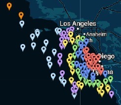
Check the latest feature to our site folks! This fully-featured Deep Sea Fishing TUNA GPS COORDINATE map basically has the top 100+ best Socal local Bluefin, Yellowfin, Yellowtail, White Seabass, and local San Diego six-pack charter fishing spots!
Additionally, the data will show you how far it is from Point Loma, in miles and approximate travel time. Using this chart you can then find the trip time that is best for you. The chart is color-coded so you can easily see which trip is best for each spot. You can interactively zoom in and out, and turn on TERRAIN mode so you can see the ocean’s bottom topography.
If you have any questions drop us a line at 619-508-7823


Comments
Post a Comment